infra3D for Basler & Hofmann AG
Precise and comprehensive project planning and design fundamentals
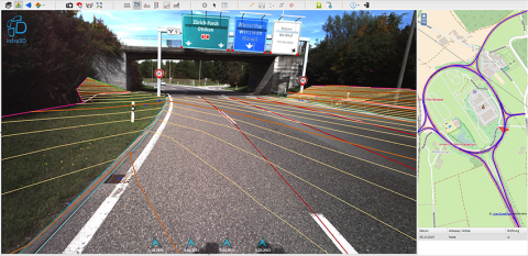
As a basis for the inventory, a section of the A53 Oberland motorway was driven on behalf of the engineering firm Basler & Hofmann in Zurich. Instead of conventional surveying methods, the infra3D Platform from iNovitas was used to capture road markings, signs, shafts, restraint systems, curbs, fences, break lines, etc. Thanks to the high-resolution, three-dimensional and geo-referenced images, all the work could be carried out digitally at the workplace and extracted in the required formats for further processing.
The challenge
On such heavily trafficked roads, conventional surveying work is very dangerous, as well as time-consuming and costly. For this reason, measuring and evaluation methods are needed that reduce field inspections to a minimum, ensure the required high measurement accuracy and, if possible, cover the road space comprehensively. In addition, the recorded factual data should be documented transparently and the digitized situation should be able to be communicated and verified in a simple manner.
The solution
With its innovative, stereo-image-based, mobile recording technology, iNovitas was able to drive along the required routes in the flowing traffic, process the recorded raw image data and make it available via infra3D in no time at all. The highway was driven in both directions twice in order to comprehensively digitize and map the road corridor of the multi-lane national highway. With the help of additional control points, the entire 3D image database was referenced with an absolute accuracy of 1-2 cm in the specified reference frame. The infra3D web client then enabled the engineering firm Basler & Hofmann to efficiently digitize all the required geodata sets using infra3D. This meant that the work could not only be carried out efficiently, safely and in dry conditions, but infra3D is also available to all project participants at any time for further information.
The customer's conclusion: massive advantages in everyday life
infra3D is used in a variety of ways by the engineering firm Basler & Hofmann: virtual field inspections, determination of any distance and area masses, mapping of inventory objects as well as correct overlaying of existing geodata. The platform brings the street space directly to the desks of engineers and planners. This saves Basler & Hofmann AG time and money.


