infra3DRail
With the infra3DRail you will stay „on track“
The operation and maintenance management of infrastructures demands a great deal of precise information about the rail corridor. The usual way of collecting the relevant data is time-consuming and associated with risks or operational restrictions.
The unique infra3DRail service facilitates the efficient and flexible collection of data direct from your work place and thereby saves time-consuming field surveys.
 Analysis of the lateral deviation and contact wire height related to the main track axis
 / Variuos measurements") Linear referencing to an existing tram axis (axis extraction) / Variuos measurements
Linear referencing to an existing tram axis (axis extraction) / Variuos measurements Automatic extraction of superelevations
") Linear referencing to an existing axis (axis extraction)
Linear referencing to an existing axis (axis extraction) Visualization / Mapping
 - Automatic extraction of rail types, track axis, track gauges and superelevations") Track Quality Control (TQC) - Automatic extraction of rail types, track axis, track gauges and superelevations
Track Quality Control (TQC) - Automatic extraction of rail types, track axis, track gauges and superelevations Perpendicular measurement / Mapping and overlaying of geo objects
 Damage detection / Rail condition analysis / Inventories and mapping of geo objects
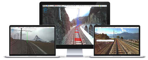

 / Variuos measurements")

")

 - Automatic extraction of rail types, track axis, track gauges and superelevations")


Applications
- Conducting virtual field surveys
- GIS mapping & inventory
- Track quality control (TQC)
- Asset management
- Project planning & design
- Project communication
- Clearance analysis
- Contact wire analysis
- Nominal/Actual axis comparison
Benefits of infra3DRail
- Efficiency
The high resolution rail corridor with unique precision brings the whole railway area into your work place and facilitates virtual inspections and efficient mapping work. You can analyse the condition of the track and develop a detailed damage pattern without previous field surveys. Determine safety distances, create inventories of street furniture, manage assets and develop restructuring measures- all can be done from your work place. - Simplicity
Web Client is simple and intuitive to use. Information can be collected quickly and simply. The numerous additional modules allow track sections to be checked simply, contact wire position to be extracted or a corridor light analysis to be done. - Integration capacity
infra3D service can link to an existing geographical information system (GIS), as well as to numerous third party systems. Existing geodata can be refined or maintained. It is also easy to exchange data between numerous different systems. - Precision
The unique precision of the infra3D image data base gives you the most precise information within the railway corridor and is therefore the ideal database for supporting an innovative, comprehensive and efficient maintenance management system and various project planning processes. - Simplification
Planning, presentation and communication of projects is simplified by the image data base because specific geodata and projects can be shown in their real context.